A 30-second introduction
Seto Inland Sea: islands, routes and environmental management
瀬戸内海
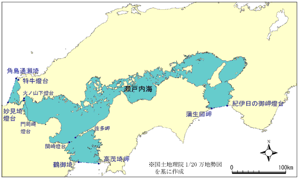
Between Honshu, Shikoku and Kyushu, the Seto Inland Sea contains connected basins, straits and many islands. Shipping, coastal livelihoods and environmental management are as central to it as scenery.

- The Kii and Bungo channels connect to the Pacific; Kanmon Strait connects to the Sea of Japan.
- The inland sea and its national park have different boundaries.
- Nutrient management depends on conditions in particular waters.
01
Connected basins and narrow passages
Basins and channels
Islands and coastlines divide the sea into broad basins and narrower passages. Tidal currents in straits affect navigation, helping explain ports associated with waiting for tides or favourable winds. This is not a sealed pool: channels connect it to other seas, and conditions vary across the region.

Navigation at Kurushima Strait
Kurushima Strait shows how currents shape a route. Vessels travelling with the tide use the middle channel, while those travelling against it use the western channel. When the current reverses, the channel used for a given direction of travel changes. The local vessel-traffic centre traces the practice to the Meiji and Taisho periods, with its first formal codification in 1929.
02
Ports and coastal livelihoods


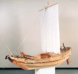
Maritime exchange connected shores from ancient times, and medieval ports supported trade. Early-modern coastal routes, including the western route and Kitamaebune shipping, linked ports, goods and merchants. Steamships, railways and modern harbours later changed transport. Fishing, aquaculture, salt-making, farming, shipbuilding and industry belong to this history alongside tourism.

03
Landscape protection and pollution
Scenery protection and water quality
Setonaikai National Park was among Japan’s first national parks in 1934, but does not encompass the entire inland sea. Postwar urban and industrial growth increased wastewater loads. Red tides and other problems helped drive 1970s regulation. Sewage treatment and discharge controls improved water quality along Hyogo’s coast from the 1980s, while red-tide incidents declined. Scenic protection and industrial-pollution control remained distinct tasks.
Cooperation among coastal governments
Cooperation crossed prefectural borders. In 1971, governors from eleven prefectures and mayors of three designated cities formed a conservation conference. Interim legislation followed in 1973 and became the Special Measures Law in 1978. A sea used by many communities required coordinated measures beyond a single local authority.
04
Managing nutrients in particular waters
Changes in fish catches and nori production involve nutrients, food webs and production conditions, among other factors. In Hyogo’s coastal waters, catches began declining in the late 1990s and nori discolouration became frequent. Insufficient nitrogen and phosphorus have been identified as one contributor. Legal changes in 2015 and 2021 supported more differentiated management. Hyogo’s October 2022 plan sought to increase nutrient supplies in designated waters while maintaining water-quality safeguards.
Check your understanding
Does the national park cover the whole sea?
No. The park and the sea have different boundaries.
Is tourism the only coastal activity?
No. Shipping, fishing, aquaculture, farming and industry also matter.
Should nutrient levels simply keep falling?
Management must consider local water quality and ecological conditions.
What does Kurushima’s “with the tide, middle; against it, west” rule mean?
Vessels with the current use the middle channel; those against it use the western channel.
Sources and images
- env.go.jp: Reference on Seto Inland Sea: islands, routes and environmental management
- pref.hiroshima.lg.jp: Reference on Seto Inland Sea: islands, routes and environmental management
- uminet.jp: Reference on Seto Inland Sea: islands, routes and environmental management
- ひょうごの環境 :: 瀬戸内海の環境保全
- env.go.jp: Reference on Seto Inland Sea: islands, routes and environmental management (2)
- www8.cao.go.jp: Reference on Seto Inland Sea: islands, routes and environmental management
- www6.kaiho.mlit.go.jp: Reference on Seto Inland Sea: islands, routes and environmental management
- 瀬戸内海環境保全知事・市長会議・設立と法制度の年表
- Environment Ministry map of the legally defined Seto Inland Sea waters, with original Japanese place labels. This boundary differs from that of the national park.
- Model of a bezaisen cargo vessel in Hiroshima Prefectural Museum of History’s display on the early modern period. Date of model unspecified.